It has been about a year since I published my first blogpost on this blog. Man, that's hard to believe. I recently figured out that I've seen 76 birds, 8 reptiles, 4 amphibians 3 mammals, and 70-odd flowers new to me, and I visited 20 nature preserves new to me, since I first started working on this blog on August 29 of last year. I've written 93 published blogposts in that time, mostly about Central Illinois. When I first started writing this blog I wasn't sure how much I could write about Central Illinois, as at first glance it appears to be a Lincoln-obsessed cornfield. It's ironic that in this particular blogpost, I'm revisiting the first place that convinced me Illinois was more than corn and soybeans. Matthiessen is one of the first state parks I visited when I was younger, and its beauty, rockiness, and large number of plant species made me far more interested in Illinois than ever before.

The day after finding that Little Blue Heron at Lake Springfield Beach, a friend and I took a road trip to Matthiessen, which is in northern Illinois, just across from Starved Rock State Park. I liked it a bit better in the past than Starved Rock, however, mostly due to its lack of crowds. That preference was tested a bit on this trip.

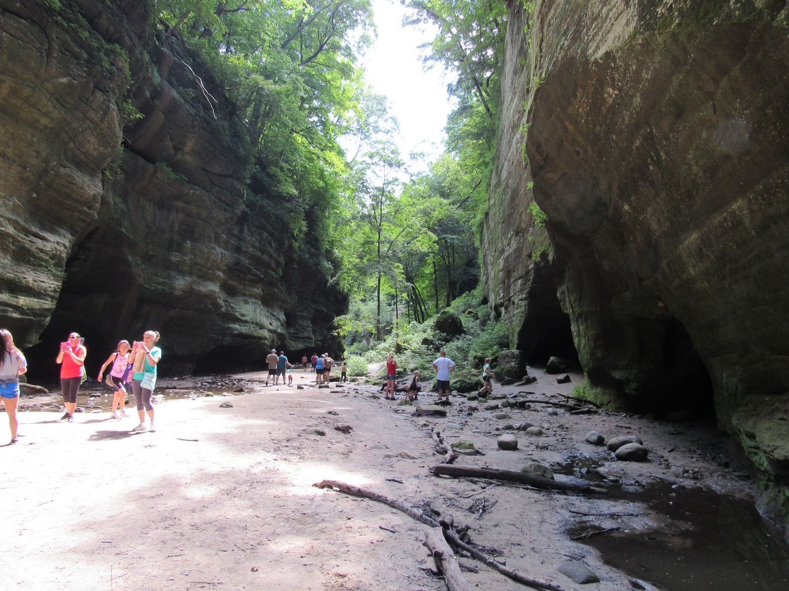
In order to explore an area neither of us had ever been to, we pulled off along the Vermilion River section of the park. This is also known as the river bluffs section, On the route in, I discovered the Hog Peanut (Amphicarpaea bracteata) above, a native plant new to me, although fairly common here in Illinois. As I've begun hiking a LOT more this year, it has become apparent that I really haven't seen many of our native plants or animals. As you read above, I've done a bit to rectify that, but not enough. Of course, there never will be enough. If there's one thing I love about exploring nature, it's that there are endless discoveries just waiting to be made.


We came to the edge of the water, as had a few bathers and fishermen, to see the rapids. Large gravel beaches opposite looked inviting, but there was no way we were crossing the river. One curious fact about the Vermilion River is that there are two of them, both flowing in opposite directions, but with headwaters in the same general area, a former upland marsh near Roberts, Illinois. This one flows into the Illinois River, and the other flows into the Wabash River. Both contain a number of high-quality nature preserves and are among Illinois' most scenic rivers. The Middle Fork of the other Vermilion River is Illinois' only National Wild and Scenic River. With a bit of sediment removal, this river could probably qualify for the same.

This section of Illinois is also among the most geologically diverse. I found crinoid fossils, granite, limestone, sandstone (the cliffs in the area are mostly sandstone) and fool's gold (iron pyrites):

Among all these rocks, I was surprised at the lack of snakes or frogs. That's not to say there was nothing interesting, as I've never seen this unusual species of grasshopper before:

Picking our way along the edge of the river, we made it to the base of the bluffs.


A degraded prairie awaited us at the base of the bluff, with several Goldenrods, among other flowers.

At the very bottom, we found wet clay. This part of Illinois is one of the few to contain claypits.

The cliffs themselves were up to fifty feet high, and the steepness of the boulder field at their base made them inaccessible. We stood at the base of the cliffs for a few minutes, before the heat and time drove us back to the treeline. After that, we had lunch in our car.

While driving to the more well-used Dells section of Matthiessen State Park, we saw that the parking lot was almost filled, and dozens of people were milling about the entrance. This did not bode well. We abandoned our plans of visiting Starved Rock, which is usually far busier at the best of times, and contented ourselves with dodging the crowds at Matthiessen's "dells".

After walking quite a ways past several screaming children, barking dogs, and noisy families, I found a Eurybia aster on top of the bluffs, with several small, brightly-colored bees or wasps on it:

Also on top of the bluffs was a state-threatened tree, the Northern White Cedar (Thuja occidentalis):

This tree is a northern plant brought this far south likely by glaciers. Several dozen of these trees grow on the rim of the "dells", actually one large canyon containing a stream flowing south into the Vermilion River- the north-flowing one. You can see why two Vermilion Rivers is confusing.

As we walked into the canyon, we found this large millipede (Narceus spp.), about four inches long. This millipede is among the largest invertebrate animals in our area. Also, yes, it is pooping.

All over the walls of the canyon, various liverworts (above), mosses and ferns grew. The permanent shade of the canyon was also about ten degrees cooler than on the bluffs above. This microclimate makes for excellent summer hiking, and there were large numbers of people around to prove that. I had to time my shots in order to avoid getting people in the picture:

This area is supposed to be an excellent place for salamanders, and I suspect that it is. However, I have never seen one. Then again, I haven't stopped to flip many rocks, which is the best way to find salamanders. As we were on a bit of a time crunch, we kept moving.

I did stop to photograph any unusual plants we found, including this fern I haven't identified.

We continued up the creek, where the creek became underlain with sandstone. Eventually, we reached the top of the canyon, at Lake Falls.

The upper part of Lake Falls is actually a dam, so this waterfall is at least partially artificial. Above the waterfall is a lake and a privately-owned golf course.

On the way back, I photographed this natural arch. A friend of mine squeezed through it, and it's certainly a tight fit. Don't try this at home, or here.

Further downriver, a fence bars access to the top of Cascade Falls, the dividing point between the generally rock-bottomed, narrower Upper Dells and the soil-bottomed, wider Lower Dells. That bridge above is where I got the picture earlier overlooking the Lower Dells.

Several mineral springs in the Lower Dells result in streams with scarlet waters. It almost seems as if the ground is bleeding in several places. Also, there's a TON of mud.

The surrounding cliffs, some fifty or more feet high and whitened with lichens, funneled the crowd as we walked towards the waterfall. I took this picture during a rare crowd-free moment. Here's what happens when I don't wait for those fleeting crowd-free moments:
There were at least a hundred people, probably two hundred, in this small, narrow canyon, splashing about in the water, complaining loudly about the mud or just bumbling about. My friend and I didn't exactly diminish the numbers, so I can't complain too much.

The area is understandably lovely, but it needs a little more protection. The first fine weekend towards the end of the summer in any natural area near Chicago does mean crowds. However, when I see people glued to their cell phones while letting their dogs or kids run free, many chiseled names in the rock that were put there since I last visited, upwards of fifty discarded water bottles (in the upper dells alone). and about a hundred people illegally swimming in every possible body of water, it makes me a bit depressed at the large crowd.

Also, at least twenty wet, muddy pairs of socks were thrown down at various points and left there. This really took me over the edge. JUST, WHY! THERE'S GARBAGE CANS FOR THIS! It's a good thing I never saw anyone throw off a water bottle or pair of socks. I mean that it's a good thing for them. Environmentalist rage is one of the purest forms of anger, and as this place was one of the parks that helped to spark my love of botany and Illinois nature, seeing it degraded infuriates me.

Thankfully, there were still many ferns to love. My friend and I decided to venture downstream to get away from the people. By the way, neither I or the DNR recommend going south of the last staircase.

At the base of the cliffs, several swamp and wet prairie wildflowers bloomed. A couple of rarer plants are supposed to be found here, but I observed none of these.

The mineral-rich scarlet waters from the largest mineral spring, Devils Paintbox, run into a nearby creek. The Lower Dells has several of these, most in varying shades of orange-scarlet.

My guess is that iron is the contaminant making the waters so red, but I really have no idea. I am fairly sure that the name Vermilion River comes from the reddish hues of these springs near its banks.

Either way, this part of the gorge has several differing fern species, none of which I identified.


The river at this point was beautiful. Slanted rocks on our side gave way to gentle rapids and a large gravel island near the far bank. Of course, a picture does it better justice. A few bathers swam upstream of us, but for the most part, the area was crowd-free. There's probably a rule against straying from the trail, and knowing the muddy conditions, I wouldn't walk that way again. Still, it was a fine day, and I'm always glad to have gone hiking. Despite the crowds and trash, Matthiessen is still one of my favorite state parks in Illinois. It's places like this that inspire me to keep working on this blog, a year from when I started it.

Hopefully, I'll still be doing this a year from now. I'd love to work on this blog my whole life. Of course, when I move out of central Illinois, it'll need a bit of a title change. Although, Abraham Lincoln lived on Earth, so I could qualify that Earth is the wild Land of Lincoln in the big picture. I do like inoffensively anachronistic titles. We'll have to see. Either way, it's been a fun year of blogging so far, and I will likely keep on blogging for awhile yet.
By the way, it's really, really hard to photograph your shadow, even when it looks almost like Indiana Jones with the hat you're wearing. Happy trails.

No comments:
Post a Comment